significant nocturnal tornado environments
|
This is a collection of observed or very carefully modified soundings/hodographs associated with recent significant nocturnal tornado events. All thermodynamic calculations are computed by lifting a 100 mb Mixed-Layer (ML) parcel and include the virtual temperature correction. I may add some other events (03/12/06, 02/23/07, 04/20/07, 01/07/08, etc) in the future.
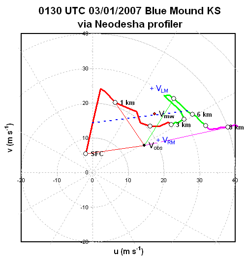
1 Blue Mound KS EF-4, 02/28/07 sounding hodograph
I modified the 00Z Topeka RAOB for this event to best represent the elevation in far southeast KS. The result should be quite "close" due to a plethora of special RAOB launches from OUN, LMN, and SGF that day, among which I interpolated. The CINH may've been weaker and low-level instability stronger if dynamic cooling acted on the capping layer, which is certainly feasible. Regardless, note the 700mb temp is around 0C... pretty "cold" considering the seasonably rich BL moisture! The hodograph is via the Neodesha profiler.
parameters:
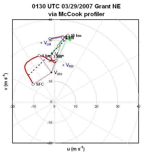
2a Grant NE EF-2, 03/28/07 sounding hodograph
These next two events occurred quite close to RAOB sites, but represent only a small portion of a deadly high plains outbreak. The flow was rather meridional for this event, but with bulk shear vectors containing enough crossover with a retreating dryline to allow for discrete supercellular mode for a few hours... nearly all of which were tornadic. The Grant, Nebraska tornadic storm was displaced a good 50 nm to the west of LBF, so the remnant capping inversion may be "overdone" on this unmodified RAOB relative to the tornadic storm. I used the McCook profiler for the hodograph to account for accelerating/backing low-level flow after 00Z.
parameters:
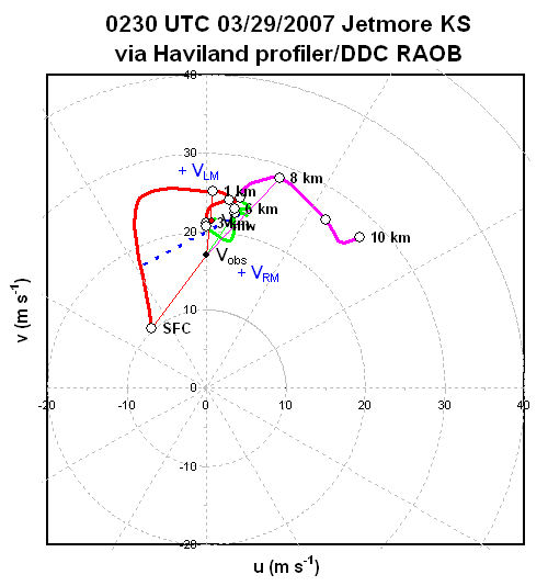
2b Jetmore KS EF-3, 03/28/07 sounding hodograph
Cooled the near-surface layer slightly on the 00Z DDC RAOB per METAR trends, due to effects of some convection in the inflow area southeast of this storm. As with the Grant case, low-level winds increased after dark so used a Haviland profiler/DDC RAOB blend for the hodograph.
parameters:
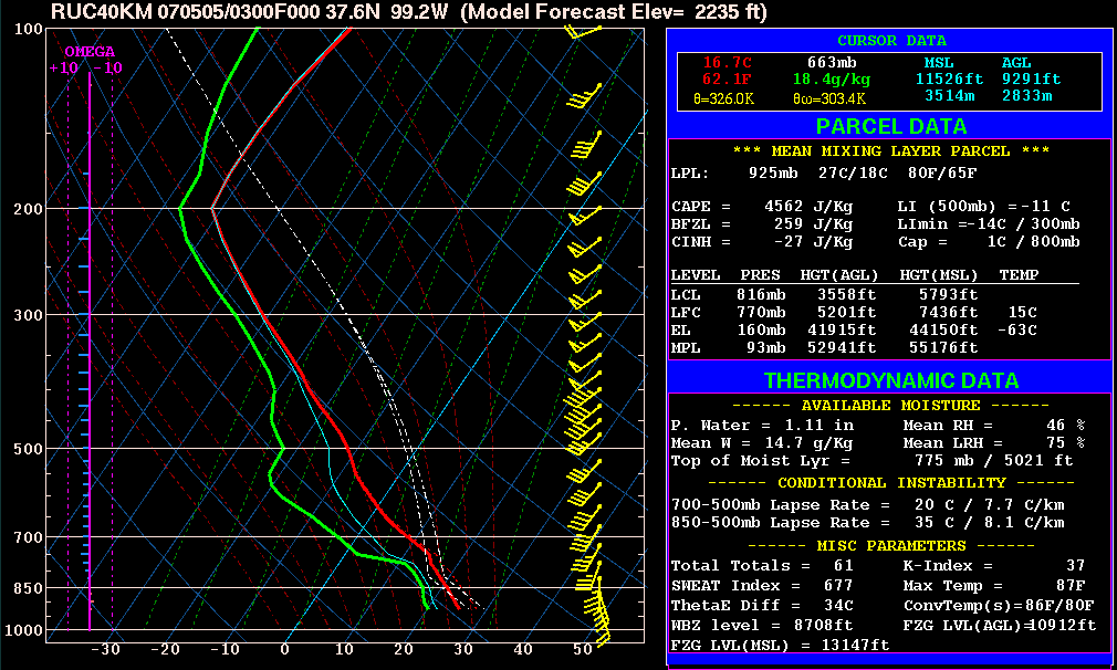
3 Greensburg KS EF-5, 05/04/07 sounding hodograph
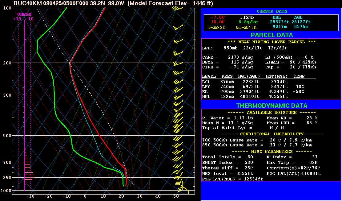
This sounding/hodograph represent the first of 4 significant tornadoes produced by the historic Greensburg supercell, but the downstream environment changed very little over the next several hours per the amazing-looking 05/05 12Z DDC RAOB. The RUC model was out to lunch for this event with the rich BL moisture shunted well east of the area (also note the deep subsidence forecast in the omega portion of the sounding!), so I carefully built the T/Td profile from scratch using trends from the AMA/DDC/LMN RAOBs that night. The hodograph is via trends from the Haviland and Vici profilers. Vici's last available ob was at 02Z... showing a LLJ of already 48 kts at 500 m, and 0-1 km of ~300 m2/s2. Haviland was unavilable until 06Z, but by then showed 750-1000 m flow of 60+ kts (!!!) and 0-1 km SRH of ~470 m2/s2.
parameters:
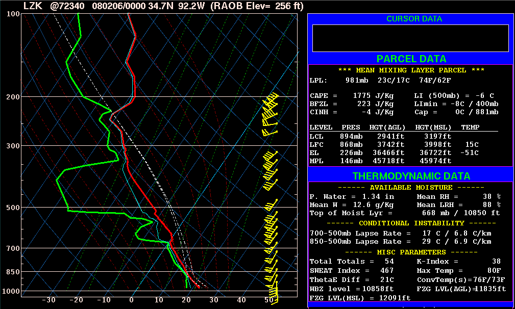
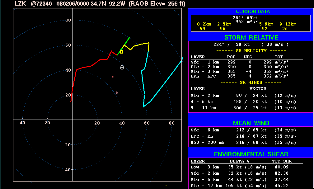
4 Zion AR EF-4, 02/05/08 sounding hodograph
This apparently is the longest-tracked tornado to occur in many years... I guess the extreme storm motion didn't hurt. Sadly, like the previous event, this tornado caused a lot of fatalities and destruction. The unmodified 00Z Little Rock sounding is used here. Note the very cool thermal profile above the moist BL, amidst strong vertical motion and complete lifting/cooling of the capping inversion... resulting again in strong low-level instability.
parameters:
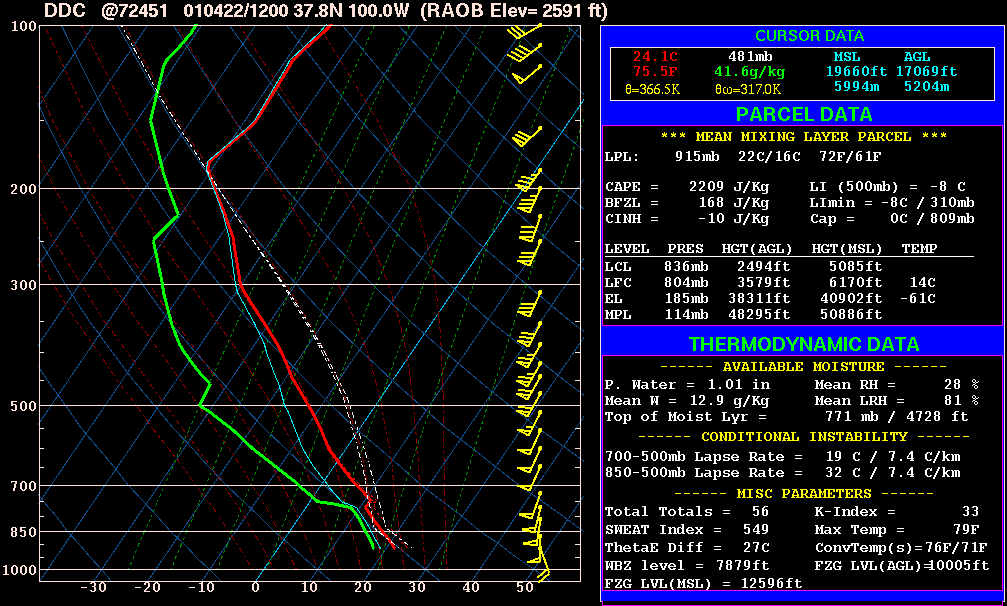
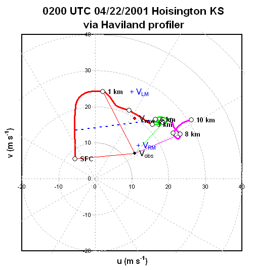
5 Hoisington KS EF-4, 04/21/01 sounding hodograph
Here is an bonus case from a few years back, since it fits pretty strongly with regard to these classical after-dark Plains tornadoes. Modified RUC data (against adjacent RAOBs) would have been ideal for this event given that the elevation can't be represented very well by any RAOB sites, but I didn't have any... so I was forced to use DDC RAOBs. The 00Z RAOB was missing above 200mb, so I used the 12Z RAOB the following morning. The 00Z data was substituted from the base of the capping inversion up to 200mb. The boundary layer was modified accordingly via 02Z METARs and 21Z-12Z evolutions at DDC/TOP/LMN. Instability parameters will be overdone a bit and CINH underdone a bit in this modified sounding, because the representative low-level T/Td are technically being forced upward onto the higher elevation at DDC's longitude. The hodograph is via the Haviland profiler.
parameters:
3 NEW 2008 CASES ADDED (as studied & presented with Jon Davies at 12th Annual High Plains Conference):
These were all very challenging forecast events, with case 2 and 3 being pretty anomalous (considerable CINH and no 0-3 km CAPE due to warm EML capping the BL).
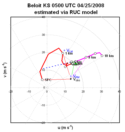
1 Beloit KS EF-2, 04/24/08 sounding hodograph
This case had strong synoptic similarities to more classical sig nocturnal tor cases of the past... e.g., strong large scale ascent emerging in the evening, modest proximal/upstream capping aloft, and northward moisture advection forecast after dark. However, the initial near-storm environment in far NW KS was excessively dry, and the BL cooled rapidly after dark in E or even ENE flow... with the LLJ spinning up farther south and later than is typical of classic cases. Then, very late (after midnight local time), a period of weakening CINH occurred as the LLJ nose finally ushered in very rich moisture and bounced the BL temps up a couple of degrees F amidst near-surface flow veering around to the SSE. The sounding is the unmodified 05Z RUC at Beloit... RUC and NAM were in excellent agreement and saw little reason to deviate from them. Note that if the BL shown had simply been a couple degrees warmer, the result would have been very small CINH and strong low-level CAPE... after midnight! The hodograph is from the 05Z RUC at Beloit as well, with minor modification to the near-surface winds based on the observed veering to SSE at CNK.
parameters:
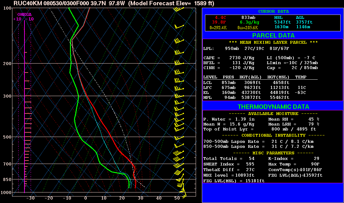
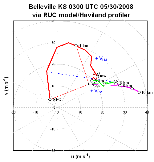
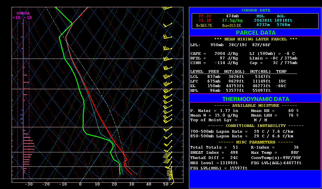
2 Jewell KS EF-3/Belleville KS EF-3, 05/29/08 sounding hodograph
Low-level thermodynamics likely became increasingly hostile in the duration of this storm's tornadic phase, as the EML expanded rapidly northeastward into the area. The modified sounding and hodograph approximate the average environment in the period the storm produced two significant tornadoes (0140-0330Z). The sounding is a 03Z NAM-RUC compromise at Belleville KS; the NAM (alongside RAOBs) was leaned on for the BL moisture given the RUC again indicated unrealistically shallow moisture (as with the Greensburg event). The hodograph is via the RUC at Fairbury (with the 02Z Haviland profiler substituted in the 2-3.5 km layer given the flow looked underdone), which very accurately forecast the LLJ evolution per profilers (NAM was too weak) and happened to have the right surface wind vector (other runs/locales were too veered/strong)... note the very impressive low-level shear with 55 kts at 500 m agl, and 0-1 km SRH/bulk shear that is anomalously strong for a warm sector tornado event in the Plains states.
parameters:
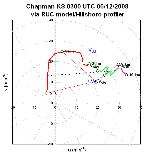
3 Salina EF-3/Chapman KS EF-3/Manhattan KS EF-4/Soldier KS EF-2, 06/11/08 sounding hodograph
This sounding and hodograph represent the environment during the first three significant tornadoes (0240-0410Z) when temperature advection in the capping layer was neutral and when CINH was the strongest. (Short-term model guidance indicated rapid cooling of the capping layer thereafter as the leading edge of strong mid-level baroclinicity/cooling overspread teh area). The sounding is a modified 03Z NAM-RUC blend at Chapman KS; both models, and even the SPC mesoanalysis, cooled the BL too quickly after dark--and also weren't quite moist enough; thus, this event wasn't quite as strongly capped as we'd initially thought.. The 03Z RUC was used for the low-level hodograph, which displayed rather strong low-level shear. Above 4 km the Hillsboro profiler was substituted, as it captured stronger mid- and high-level flow than forecast by any of the models. The deep layer shear was out of control for this event considering the time of year at that latitude; 6 km flow was as strong as 70-72 kts!
parameters:
Summary:
Below is a summary table with a few of the key parameters from the recent Plains events. The more classical events are in red; with the more challenging/uncharacteristic events of Spring 2008 listed in blue. I've included low-level T/Td values to give a comparative sense of the low-level thermodynamic structure in each case. The 700 mb temperature can be considered a "proxy" for the relative strength of the capping inversion.
In the 2007 cases, modest capping aloft coupled with rich boundary layer moisture and relatively slow BL cooling amidst the accelerating LLJ were key in keeping these storms strongly surface-based after dark. On 03/28 and 05/04, it could clearly be argued that the elevation played a role in keeping CINH weak after dark, with the deep/moist boundary layer having retreated onto the elevated terrain of the high plains--helping minimize the depth of the capping aloft. Also note the near-extreme magnitude of CAPE on the Greensburg event... including very strong low-level instability.
In the 05/29 and 06/11 events of 2008, the warm EML aloft led to considerable CINH and no 0-3 km CAPE. Note the anomalously strong low-level/deep layer shear profiles in those events, though, combining with moderate to moderately strong CAPE to produce strong to very strong CAPE-shear combinations. These are assumed to have had a strong hand in allowing the storms to be cyclic sig-tor producers in spite of low-level stability. The 4/24 event was a bit different, with a shallower stable boundary layer...and cool capping aloft allowing some 0-3 km CAPE above the stable layer. |
| Event | Sfc T/Td (F) | ML Td (C) | 700 mb T (C) | MLCAPE (J/kg) | MLCINH (J/kg) | 0-3 km MLCAPE | 0-1 km SRH (m2/s2) | 0-6 km shear (kt) | 0-1 km MLEHI |
| 02/28/07 | 64/55 | 12 | 0.0 | 1075 | 28 | 46 | 321 | 64 | 2.2 |
| 03/28/07a | 66/58 | 13 | 5.6 | 2081 | 2 | 46 | 187 | 52 | 2.4 |
| 03/28/07b | 66/61 | 15 | 6.0 | 2886 | 10 | 96 | 204 | 37 | 3.7 |
| 05/04/07 | 77/68 | 18 | 8.5 | 4562 | 27 | 167 | 358 | 51 | 10.2 |
| 04/24/08 | 66/64 | 17 | 6.1 | 2178 | 71 | 47 | 405 | 37 | 5.5 |
| 05/29/08 | 75/69 | 19 | 13.1 | 2730 | 120 | 0 | 648 | 60 | 11.1 |
| 06/11/08 | 81/68 | 19 | 12.5 | 2004 | 114 | 0 | 524 | 71 | 6.6 |