May 22 2004 chase


Several targets existed in the central plains on this chase day due to the potential for various initiation mechanisms.  I chose to target a progged dryline bulge,

and it paid off.  My experience with this classically cyclic supercell, which went from clump of cumulus to tornado-producer a little over an hour, was literally hair-raising. 

Unfortunately, the two tornadoes I observed were not meant to be photographed due to low light and enormous amounts of rfd- and tornadic-driven dust.  The first tornado

emerged as a full-fledged wedge from behind a towering wall of dirt northwest of Alexandria.  Intermittently defined by lightning flashes, the tornado moved north-northeast

along side highway 53, eventually crossing it and dissipating shortly thereafter.  The new mesocyclone—seemingly a mirror image of the first—formed rapidly a few miles

to the east, resulting in a beautiful white cone tornado just northeast of the town of Daykin.  This tornado moved nearly due east and quickly became choked with dirt,

taking on a wedge appearance.  Scarily, the left-side wall of the low-level meso appeared to descend to ground level before the tornado dissapeared into the murk

to my northeast.  The tornado would later reached F4 intensity and purportedly break the all-time record tornado width when the circulation grew to 2 ½ miles in diameter.


Images


I've re-visited this page some 4 years later to add additional photos.  This is a shot taken from Highway 81 halfway between Concordia and Belleville, looking west at cumulus starting to develop on the bulging dryline.  I had run into Jon Davies at the Concordia library, and we strongly agreed on a target near the NE-KS border along Highway 81.  Staying put required some resolve given the ongoing tornadic supercell near Beaver City (WNW) and explosive development along the stationary front near Columbus (well NE).


553pm: we gassed up in Belleville as the cu field deepened and expanded eastward toward us.
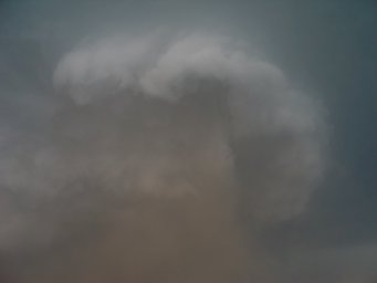
602pm: as we neared the state line, the towering cu evolved directly into this CB over northeastern Jewell/northwestern Republic county.  this was the birth of the Wilbur/Hallam tornadic supercell.
608pm - just north of the NE state line on the way to Hebron, still looking west at the developing CB
621pm
624pm - storm began to anvil out aloft.  in the upper left, note the sun shining thru milky anvil cirrus streaming downstream of the Beaver City tornadic supercell.


630pm - rounded updraft base evolved


636pm - horizontally rotating cloud formations overhead
637pm - storm developed supercell characteristics, but remained somewhat high-based
644pm
647pm - just southwest of Hebron, a wall cloud condensed explosively beneath the RFB and began rotating violently.  note the absolutely gorgeous bell-shaped updraft above, which in hindsight i wish i'd attained more photos of.
648pm
651pm
657pm - I was tempted to head north out of Hebron, but Jon suggested we go east first and then north.  His good instincts were critical in us capturing the visible phase of the upcoming "Alexandria tornado."


711pm - After heading east to Gilead, we moved north on Highway 53 as shown here.  A well-defined collar cloud is pictured, with a large tornado probably already ongoing in the distance.  Huge sheets of dirt being lifted by the RFD as well.

714pm - we lost sight of the storm while moving through the town of Alexandria.  Upon exiting the town to the north, we immediately encountered the most ominous sight I had ever encountered in stormchasing.  This included a wall of RFD-driven dirt shrouding much of the business end of the storm, as shown here looking NW.

714pm - stark white collar cloud above, with strong/turbulent motions
714pm - wildly spinning (and apparently anticyclonic) funnels aloft, one pictured here in lower left
715pm - low-level meso became visible as dust parted momentarily
718pm - an enormous plume of dirt consolidated and was lifted to a ridiculous height while moving beyond the low-level mosocyclone.  A large dirt-choked tornado was subsequently revealed.
718pm - close-up detail of the departing wall of dirt; the back side of the tornado; the trailing train of RFD-driven dust; and in far lower left in front of the train of dirt, a car's headlights heading east (left-to-right)
719pm - lighter-colored low-level meso above descended temporarily and wrapped around the dusty tornado
719pm
720pm - cloud material breaks up around the dusty tornado, resulting in an interesting carousel of color
720pm - crop of previous photo
721pm - video capture showing lightning backlighting the wedge tornado
724pm - the tornado became obscured by rain and dust.  we headed north, and gradually the tornado reappeared.  note the RFD cut above.
726pm - the left-hand side of the strongly occluding wedge tornado became very apparent immediately to the northwest.  shortly after the structure wrapped back up in heavy rain... and did little damage when crossing Highway 53 ahead of us.


we moved swiftly east on Highway 4 toward Daykin.  cyclic development of a new low-level meso occurred explosively to our ENE, just as rapidly as the previous event.  despite my inexperience, I stated on camera when entering Daykin that "a tornado will be on the ground when we come out of the other side of town."  this vidcap at 735pm shows the Daykin watertowrs, with the forward edge of the low-level meso behind it.  a cone tornado was in fact on the ground.

735pm
736pm - backlit by lightning
736pm - same
736pm - same
736pm - myself pictured in front of the increasingly dirt-choked tornado
736pm - cone tornado completely wrapped up in dirt and debris
737pm
737pm
737pm
738pm - shortly after, the entire low-level mesocyclone appeared to descend and wrap around the dusty tornado.  visibility became very poor as the tornado headed ENE away from us.
745pm - police blocked off the next paved N option, and the chase more or less ended here.


Soundings, maps


observed tornadoes
 

Daykin-Hallam tornado track courtesy of NWSOAX

         
radar loops

01Z modified sounding for Daykin-Hallam, NE (based on OAX/TOP RAOBs)

Sfc T/Td: 82/67 F

MLCAPE: 3709 J/kg

MLCINH: 2 J/kg

0-3 km MLCAPE: 109 J/kg

MLLCL: 1260 m

MLLFC: 1260 m