|
The tornadic storm that tracked from Picher OK through Seneca/Newton/Purdy MO caused an unnerving number of casualties. The event itself ended up being a fairly difficult forecast on a number of counts, made even more difficult for stormchasers by the rough terrain over which it occurred. In the end, the forecast challenges (some of which were handled poorly by short-term model guidance) included: 1) how far north would substantial destabilization occur in the wake of elevated activity; 2) how far south away from the primary DPVA would convective initiation occur; and 3) how quickly would veering low-level flow inhibit potential tornadogenesis. It seems as though many stormchasers who departed the night before or early the morning of--myself included--were particularly afraid of point #3... and stubbornly stuck to the warm front target in Arkansas, despite models trending toward a better shot at tornadoes farther west right off the prefrontal trough.
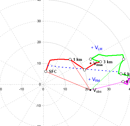
Someday I may get more closely into the forecast challenges as they played out that day, but for now I've just reconstructed the environment of the deadly Picher OK tornado. For the sounding, I simply modifed the 00Z Springfield MO RAOB. This observation was quite proximal to the tornado, but to the cool side of the warm front... thus I modified it to represent the warm sector environment in far northeast OK. Note that I didn't attempt to alter the saturated upper levels on the sounding (anvil blow-off downstream of the supercells) as the effect is pretty negligible. Meanwhile, for the hodograph, I used the 21Z Tulsa VWP data through 3 km agl, and a 70%-30% mix of the SGF-OUN RAOB winds above that. The low-level hodo should be especially representative, given Tulsa's position relative to the prefrontal trough at 21Z was similar to the tornadic storm's relative position was around 23Z. The Springfield RAOB had a nice sickle-shaped hodograph and over twice the 0-1km SRH (using the Picher storm motion) of the one I've created... but the surface-500m agl flow to the cool side of the surface warm front was far too backed to be representative. In general, this is definitely one of the most impressive long-track/damaging/deadly tornadoes I've seen occurring with an LLJ barely exceeding 30 kt and somewhat-modestly-strong SRH. On that note though, both the low-level thermodynamics and low-level shear of the Picher near-storm environment were more than likely changing substantially in time and space in that narrow wedge (as opposed to having an event with a larger/homogenous/non-changing warm sector)... so who's to say for sure. A second note: I changed the mean wind depth on Bunker's hodograph program from 6km to 8km, and it increased/veered the right-moving supercell motion to something closer to what was actually observed. The storm was strongly rightward-deviant.
The other most substantial tornado of the day occurred from the middle of the tail-end three cells over southeast OK. Video of this high-contrast tornadic supercell near Yanush OK (see youtube) has some of the most incredibly violent motions I've ever seen, though the tornado is generally behind a ridge line and thus its tough to tell for sure if its motions were as strong as seen in the parent meso. The tornado didn't have a whole lot to hit, and was rated a high-end EF-2 as a result. Below is a reasonably representative hodograph for the storm via a 00Z DeQueen AR profiler/OKC-LIT RAOB mix. Note the WSW LLJ, which was actually favorable for hodograph curvature and SRH (a bit tough to imagine in this part of the country in early May... reminiscient of the very "veered" 04/02/06 event through the MO bootheel). Still, even with the veered storm motions, SRH was still just in the moderate range (a bit greater than 200)... and the apparent strength of this tornado thus surprises me. (WFO Tulsa's mesoscale update AFD wasn't too excited about tornado potential either, and indicated that based on the storm motions the southeastern OK supercells only had 0-1km SRH near 100 m2/s2... perhaps a bit underdone but still in line with my thinking). In hindsight, in contrast to the SRH, nearly all other parameters were fully maximized: strong to very strong deep layer shear, ridiculous mid- and high-level SR flow with a 125 kt jet at 10 km!; and very strong instability likely, including the ideal low LCL-LFC combo as per the modified Picher sounding I created. Thus, that was probably a strong contributing factor.
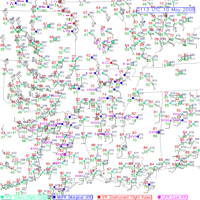
21Z surface map (unanalyzed)
23Z Picher OK modified sounding sounding/hodograph
Sfc T/Td: 76/67F MLCAPE: 2816 j/kg MLCINH: 2 j/kg 0-3 km MLCAPE: 130 j/kg MLLCL: 901 m MLLFC: 1042 m
storm motion: 280 @ 45 kts 0-1 km SRH: 266 m2/s2 0-3 km SRH: 403 m2/s2 0-6 km bulk shear: 67 kts 5 km SR wind: 41 kts 7-10 km SR wind: 37 kts
23Z Yanush OK modified hodograph
storm motion: 289 @ 33 kts 0-1 km SRH: 209 m2/s2 0-3 km SRH: 231 m2/s2 0-6 km bulk shear: 66 kts 5 km SR wind: 35 kts 7-10 km SR wind: 67 kts
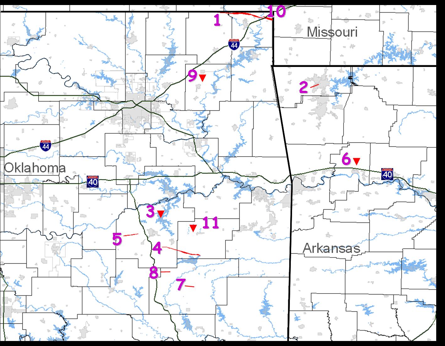
Picher OK and Yanush OK tornado tracks courtesy WFOTUL
other links:
|